Around Lake Superior
AROUND LAKE SUPERIOR
GUY WEBSTER
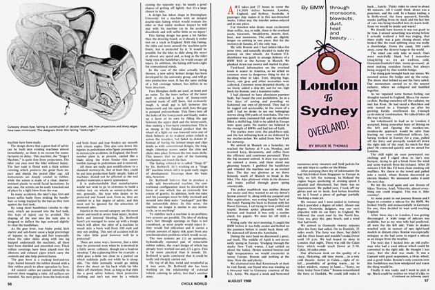
You DUMBBELL!" I thought to myself. Here I was twenty miles north of home (Milwaukee, Wisconsin) on my first long motorcycle trip and I had forgotten the cycle title and my birth certificate which AAA had advised me would be necessary to cross the Canadian Border. So I turned my BMW homeward for the missing paper and set off again on my first leg: Milwaukee to Minneapolis.
I've been riding motorcycles off and on for about 8 years, but only on local jaunts or as transportation at college. Last year I decided the time had come to take a trip using my "hobby" as transportation.
Having lived in Milwaukee for a time, I had heard how beautiful the road around Lake Superior was in the fall. I had but one week and was advised the trip could be taken "leisurely" in only five days.
My first step was to have my old '56 BMW R-69 tuned. Rather than attach a rack to the rear fender I decided to fasten my bag to the top of the gas tank — figuring this was wasted space anyway and then the center of gravity would be better. I spent a month full of anticipation and apprehension sorting the few things which I would wear and take along with me in my bag. The most important were a change of clothes, nylon rain suit, gloves, camera, fishing rod (attached to the side of the cycle with tape), extra shoes, underwear and a small toilet kit.
I first rode to Minneapolis to stay with a fellow insurance adjuster. This leg of my trip was about 360 miles and I was encouraged to go this distance in one day's travel. The Wisconsin countryside shone in its late summer green and beginning fall browns and the day was sunny and warm.
My rear view mirror glass fell out and broke — the only catastrophe of the day -and I stopped at an auto supply house and bought a square auto visor mirror which I held on with rubber cut from bicycle tubing. It worked fine and actually gave a much wider field of vision than afforded by the original small mirror.
Upon leaving Minneapolis I traveled north to Duluth, Minnesota, the American Lakehead and the western end of the St. Lawrence Seaway. Duluth-Superior harbor is cut off from the open lake by two narrow points of land. Minnesota point is on the north and Wisconsin point on the south. These two points form a landlocked basin with a water frontage of some 49 miles. Spanning this ship channel is the Aerial Lift Bridge which lifts 120 feet in less than 60 seconds to allow lake and ocean-going vessels to pass underneath.
I had been a seaman on the ore carriers while in college and seeing these ships laboring slowly in and out of this great harbor kindled memories of the days of hard work, good food, and no liberty. Duluth is built on the steep sides of the harbor and some of the streets ascend at such acute angles that they are impassable in winter. Duluth has seven huge ore docks at which the ore ships tie up to take on the iron ore. The ore comes tumbling into the boats from high bins with chutes attached to their bottoms.
I stopped for a visit in Two Harbors, Minn. (27 miles north of Duluth), another ore-shipping point for thousands of tons of iron ore and here I took pictures of the largest steam locomotive I had ever seen. In Two Harbors, I was warned at a gas station to watch for deer and bear crossing the roads between there and Grand Marais (85 miles northeast). As the attendant put it, "If you hit a bear, he'll eat what's left of you with relish." So with this cheery news and darkness approaching I pushed on to Grand Marais. Along the way, huge shadows seemed to be coming across the road but none materialized into a moose or bear. Tall blueblack pines reached to the sky and small hamlets appeared and then disappeared to the right and left. All the towns had their signs calling the tourist in for "Smoked Fish" or "Moccasins" or "Deerskin." The road was excellent with some twists and turns and hills; I was a little sore in the rear this second day and my throttle hand ached, but I felt I was learning.
In Grand Marais, I stayed in one of the family-run groups of cabins. It was very clean and neat — with good food. After dinner, I was really ready for bed.
The next morning I visited Grand Portage National Monument which is at the beginning of a rough nine-mile overland hike climbed by fur traders and voyagers wanting to get from Superior's shores to the inland lake country. Today was overcast and it looked like rain but I set out for the Canadian Border — 30 miles away.
At the border, I was asked only "Who are you?" "Where are you going?" and "How long will you be in Canada?" I asked the border guard if he would like to see the cycle's registration papers and he asked, "Why, did you steal it?"
The border is crossed by a high bridge over the Pigeon River. Just past the border station, a sign announced that I had 493 miles of cycling in the Province of Ontario ahead of me. The road followed the crystal blue Pigeon for about 5 miles. Along the river were hundreds of white birch and just above the birch were the maples which were beginning to turn the reds and yellows of Fall. Then I came on to a brand-new road heading to the northern Lakehead Cities of Port Arthur and Fort William.
Then the rains came and I was offered shelter and a cup of coffee by a young French-Canadian couple who ran a small "B/A" or British-American gas station and general store. The rain lasted about two hours during which time we discussed Canadian prices, American prices and our respective homes. They were very friendly and anxious to visit. After the weather cleared a little, I finished my third cup of coffee and eighth oatmeal cookie and reluctantly left in the direction of Port Arthur and Fort William. These two cities are the largest grain shipping terminals in the world. By now, it was again looking like rain so I put on my rainsuit in hopes of riding through the storm to my evening stop at Nipigon, Ontario. It rained and rained, and the wind turned vicious, pushing the cycle from side to side as the rain changed to hail. I could see clear sky ahead and so continued on for about 25 minutes of the worst riding I've ever had until I passed through the storm.
(Continued on Page 51)
After the storm the country seemed to be somehow wilder and colder - with bigger trees, larger rocks, fewer houses, and even fewer gas stations. I stopped in a small cafe attached to a gas station and ordered coffee - more to warm my hands than to drink - and then drove on to Nipigon.
The hotel in Nipigon was small and seemed very old but it was clean, and reasonably priced. It was run by an old Canadian couple who told me I was the first cyclist to stay with them. I asked where I could put the cycle to get it off the street and they took me to the rear of the hotel where they kept their car and "watch dog." The dog was a small brown Scotty-looking glob of fur with the bark of a St. Bernard. He inspected the cycle as only dogs can, baptized the rear tire (in acceptance, I guess), and took up his sentry duty.
Thursday dawned cold and clear, so clear in fact, it seemed as if I could see for miles and miles. The temperature was 37°. The surrounding countryside grew more colorful and rockier. There were small lakes to the left and right all along the road. My thermal shirt, sweatshirt, jacket, and rainsuit helped keep rre warm.
The road was a wide, two lane highway with about six foot asphalt shoulders on each side — and very fast. The speed limit is generally 60 mph. As I left Superior's northeast edge to go inland to White River, Ontario, the terrain leveled somewhat. There were many small lakes and signs reading "Moose Crossing for Next 22 Miles." Once, I stopped to take a picture of the cycle by a particularly picturesue lake when the machine fell over in the sand on a slant toward the lake. After lifting and straining and cussing — I was finally able to right it again.
White River, Ontario came into view at about 5 p.m. This town is known as the "Coldest Spot in Canada" and it was only 37° when I pulled in! The hotel and its food were excellent — the best I'd had in Canada so far. The town had no T.V. and the only radio program was the CBC which the townspeople listened to constantly. The people here were very helpful, friendly, and interested in my trip.
Friday morning, the temperature was only 35° and I bought another pair of gloves for more protection from the cold. "Moose Crossing" signs were again in evidence and finally, on my last day in Canada, I saw my first moose! He walked as slow as you please up to the right side of the road, watched me as I passed, and then strolled calmly across to the other side. Meanwhile I was braking frantically in case the monster decided to trample me on the way across.
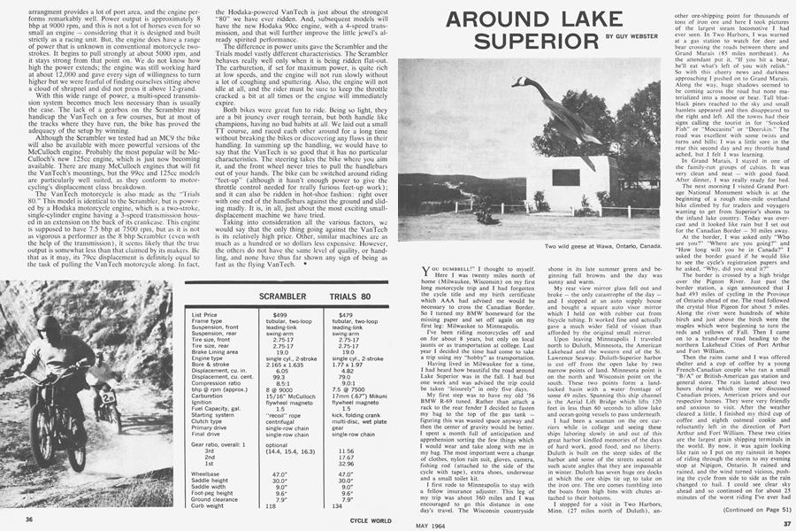
When I reached Wawa (Ojibway for "goose") I was nearing the shore of Lake Superior again and heading south toward Sault Ste. Marie. Wawa is the little mining town where the Lake Superior Circle Route was dedicated and there is a large steel goose statue commemorating this fact high on the left side of the highway. From Wawa south almost to the Soo Locks there is lakeshore and woodland scenery which surpassed any I had seen so far. Many dramatic views of Lake Superior appeared as the road wound among high and low bluffs.
Upon reaching Sault Ste. Marie I crossed the new International Bridge, cleared customs on the U.S. side, and stopped to watch a new Ore Boat lockup the 25-foot height between Lake Huron and Lake Superior. I spent Friday back in the U.S. and headed home the next day.
The Lake Superior Circle Route was never boring or uninteresting as there was much to look at; white birches along the streams and by the lakes, tall pines by the road, and clear deep-blue lakes on both sides. The road is excellent for motorcycles — flat, paved, wide, and with no sharp blind curves. Accommodations are clean and reasonable, campsites are plentiful, and the Canadians are interested and friendly. How about a Lake Superior vacation for you next year? •